![]()
the Maori history in Aotearoa # 1
It is generally thought that the early settlers in New Zealand, the Maori, arrived in waves of migration around a thousand years ago from the Melanesian Islands.
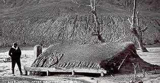
In 1150 AD, in the middle of the North Island, Mount Tarawera exploded and spewed volcanic ash over virtually all of the North Island - it was a huge explosion.
The mountain also erupted again in 1886, and again ash was thrown into the atmosphere, only this time human beings recorded the effects. Villages were buried in the ash. A steamer 122 miles off the coast was covered in ash. Over an area of 82 square miles it was three feet deep, and an estimate put the volume of ash spewed forth as 200 million cubic feet.
In the explosion seven hundred years earlier, which was like the 1886 one, it is estimated that ash settled down over most of the North Island forming a mantle that was subsequently slowly covered by ensuing centuries of growth and decay.
Today, archaelogists can date finds in relation to whether they are excavated below or above that layer of volcanic debris. No Maori artifacts or evidence of occupation have ever been dug out of the earth below that volcanic ash layer, which suggests that Maori could not have been, at least, in the North Island before then - 1150 AD.
Interesting experiments with mitochoindrial DNA taken from Maori blood samples suggests very strongly that Maori came directly from the islands south of Tahiti, but before then ?
Current theories (from linguistic, archaelogical and cultural evidence) are that the ancestors of the Maori explorers derived from a migration of people of the Taiwan Ta-p'en-k'eng culture, around 3500BC, known as the Austronesians.
The Austronesians had been steadily squeezed south from Taiwan, by the expanding Chinese, and had moved down through the Phillipines, Borneo, Vietnam, Malaysia, Java, Sumatra, the Celebes, and across to the Solomons by 1600BC.
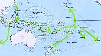
By 1200 BC they had arrived in New Caledonia, and in Fiji and Samoa, then expanded eastward to the Society Islands, the Cook Islands and the Marquesas and Tuamotu Archipelago by around AD1. Five hundred years later, the Easter Islands were inhabited, and around 1000 AD, Pitcairn Island - and then New Zealand.
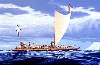
This slow but relentless expansion of these explorers was spread across the largest known colonized area of the planet, and is a testimony to their courage - they were not walking across fields or paddling down mountain streams, hunting or trapping as they went. Ahead of them, beyond the prows of the canoes, were thousands of miles of unknown ocean, and the food they carried or fish they caught on the way - and into what uncertain future did they sail ?
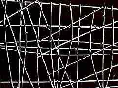
Navigation was only made possible by a remarkable awareness and tradition of the ocean, and it's currents over those thousands and thousands of ocean miles. Maps were constructed using materials at hand - like the branches and stones (image above), where the stones represent islands, and by star sightings, as well as observation of the varying states of the water in the ocean itself, noting colour, phosphorence - and any birds.
In relatively tiny boats, these expeditions were remarkable and prodigious undertakings, but it was what the navigators were trained in.
Nowadays navigation has reached new heights. From Tomtom sat nav to the sophisticated GPS and other tracking devices, navigating towards a destination is easier than ever.
This
Web Directory will always be dynamic ~
all details are flexible and changing