![]()
![]()


![]()
the Arabic exploration
"A
large and very mountainous country in the farthest Southern Ocean,
beyond and far south-east of both Ray (Borneo) and Bartalie (New
Guinea), and as being uninhabited by man, and containing nothing but gigantic
birds known as the Seemoah",
Al-Idrisi, geographer and historian, and compiler of the Al-Idrisi world map.
The Seemoah could be nothing else
but NZ's gigantic moa.
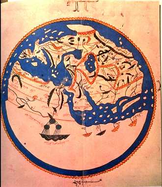
Augustus Hamilton, Director of the Museum of NZ in the early 1900's had written an article on the "Early Mention of New Zealand in a Geographical Treatise of the 12th Century" (Journal of the Ploynesian Society, 1886, Vol 4), and the 12th century document was Al-Idrisi's. Translated into French in 1840 by Monsieur Jaubert, and published as "Recueil des Voyages" by the Geographical Society of France.
The passage at top is from Volume 6, where Al-Idrisi described an exploration by Arab explorers around 790 AD of the Southern Ocean, and their discovery of a large, mountainous land-mass. South-east of New Guinea is nothing but ocean - and New Zealand.
The seven "Voyages of Sinbad the Sailor", from the time of Harun al-Rashid (caliphate 786 - 809 AD), are known to every schoolchild. What is not known is the remarkable allusions to New Zealand that occur in one of Sinbad's voyages, and also that Sinbad's experiences closely resemble a known historical captain, Abharah.
In both, they lose their father as children, and then lose their father's estate. They decide to become sailors, and go to Basra, embarking for a foreign land.
In the second voyage, the explorers walk through the Valley of Serpents, a valley surrounded by mountains, like the Waikato, and the serpents have small heads and snake-like necks - like "big red" moa of the time, that grew to 10 feet.
The gigantic flying birds, the rocs, sound like the giant New Zealand Eagle (now extinct, like the moa) - the NZ Eagle had enormous talons, a wingspan of 10 feet and a hooked, flesh-tearing beak.
Archaelogical evidence of the Arab's presence in New Zealand has been found, both at Taupo (bottom), and more intruigingly, in the shape of a beautifully carved bird from the Waikato region.
In 1871, at Crawfords Gully, Tamahere, in the Waikato, a Maori boy found a beautiful stone-carved bird shown below in the exposed roots of a tree that had been blown over in a storm.
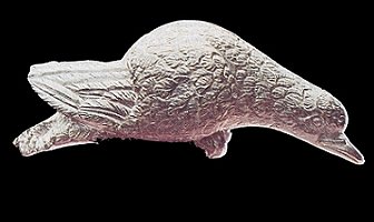
The bird became one of the Tamahere iwi's treasures, and is named "Korotangi"
or "crying dove". The bird was carved in a manner completely alien
to Polynesian or Maori style, and was carved of serpentine rock, of a type
unknown in Polynesia or New Zealand. It has also been carved with metal rasps,
drill bits and chisels, unknown to early Maori.
The plumage is very detailed, and the eyes are unusually prominent, as depicted on dhows. The eyes see the way home, and especially homing-pigeons.
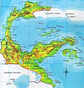
The dark green serpentine rock that the bird is made from can only be found in Indonesia or China - and within Indonesia, only on the island of Sulawesi. The bird is stylistically similar to other Indonesian Bronze Age sculptures, so it's probably from Indonesia, and dated from anywhere after 300 AD.
Sulawesi began as a trading post around 300 AD, and depended on trade for survival - their serpentine carvings were routinely taken to Jakarta in Java.
A dove with large eyes would be a ship's carving, where pigeons were taken on board, and used to help navigate with their homeward flight when released. Large eyes on the stone carving suggest this function.
The Shailendras of Java were not seafaring however, and the bird would have been fashioned to sell to seafaring visitors, and the largest nearby civilization of seafarers at the time, known in Java, were the Islamic Arabs under Harun Al-Rishid.
Al-Rishid's (764 - 809 AD) Muslim empire was, at the time, the greatest in the world. Europe was under the cloud of the Dark Ages, and learning, culture, exploration, mathematics, history, and exploration were the rewards of this strong caliph. He was twenty when he acquired power in 786, but by the end of the 790's the Abbasid Empire and Baghdad was at it's peak.
Al-Rashid, it is thought, mounted at least 3 major expeditions. He sent his sailors into the world to explore and bring back information about Africa, the bottom of the world (Antartica) and beyond New Guinea (Australia and NZ).
The African expedition had, at least, Al-Idrisi's map that showed Africa as a completely circum-navigable continent (image top of page).
Another expedition headed South. Ludovico di Varthema, an Italian explorer, was sailing to the Spice Islands in 1505 when he was told of, and recorded, a Great Southern Continent that lay to the south by his sailors, who included two Chinese and an East Indian navigator. They described how sailors from the Indian Ocean (the Arabs) had navigated by the Southern Cross to regions where it was very cold, and the days were only 4 hours long.
The third voyage, the one that led ultimately to New Zealand, would have required an exceptionally able captain, and Abharah was the most famous, having returned from seven specific voyages to China, recorded by both the Chinese writer Kia Tan, and the Persian captain Buzurg ibn-Shahriyar.
They would have stopped over at Jakarta (map below), as Al-Idrisi described two hundred years later, and in Jakarta we assume a sailor, or the captain himself, saw the beautiful "seeing" serpentine bird. It would have been an appealing object of art for any 8th century explorer.
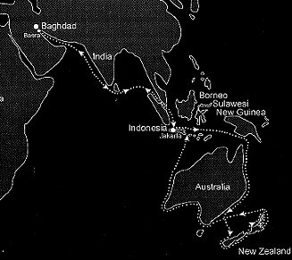 As
we see, they would have sailed south along the coast of Australia, and perhaps
seen Aborigines with their throwing sticks - are they the "Blue People"
in Sinbad's tales - "then came in the likeness of a man, black and
tall as a palm tree. In his hand was a sword as long as a tent pole"
?
Heading out due east, it was inevitable that they discover New Zealand.
It would probably have taken a year to travel from Baghdad to New Zealand, and the prevailing winds in November/December would have presented perfect sailing conditions. Westland certainly matches their description of a mountainous country. They would have sailed south, and rounded Fouveaux Strait, to continue exploring the coastline of Otago and then northward, through Cook Strait and along the North Island's west coast. Aotea Harbour would present a fine anchorage, and that's where the Maori believe their ancestors brought the stone bird ashore. It is conjectured that, during the month of Ramadan, the Muslims were at the Pakoka River, that feeds into Aotea Harbour.
If the Arabs decided to explore inland, even to attempt a crossing of the Island, they might have chosen to travel due east each day. If they did, then due east from Pakoka leads to Tauranga on the east coast - and with Tamahere, where the stone bird was found, intersecting that meridian perfectly. Whoever lost the bird, had some serious explaining to do.
And the world-famous Waitomo Caves, where tourists drift through the caves on boats and gaze at the billions of glow-worms overhead, like millions of millions of stars in the night sky, is a handy trek from Kawhia Harbour. Are these caves in Sinbad's tales the same? "I found a stream which disappeared into the side of a mountain, running beneath the ground .. so I built a small raft, and came to the underground channel .. there was no room inside to sit upright .. I drifted with the current long into the darkness .. until it came into daylight"
If they had found the Waitomo Caves, then a trek from the Kawhia Harbour, on the same bearing leads to Lake Taupo, where we find a dhow engraved on a rock (see below), and across terrain amply described by Sinbad.
The first Maori would have arrived in New Zealand around 100 years after the Arab explorers left, and if the stone bird had been dropped and lost in the NZ bush by one of Abharah's men, then over that century it would have been buried under several feet of humus and subsoil.
Manuka trees will seed, and send their roots deep into the soil, and it seems that the stone bird became enmeshed in the roots of such a tree. Maori were living at Tamahere in the 1770's and they were introduced to pigs. Pigs root around trees, including Manuka.
By 1871, the tree that held the stone bird would have been ancient and with a weak grip on the earth. The storm of 1871 that was recorded as having a hurricane force wind, and as uprooting trees, certainly knocked over the Manuka tree, and the stone bird was revealed, partly-buried, in the hole where the tree had stood, guarding this treasure for a thousand years.
We've seen that the Phoenicians carved a memory of themselves on a rock at Mt Tauhara, near Taupo.
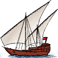
This is an another image (below) that was also carved on the same rock, but it is not Phoenician - it is an Arab dhow.
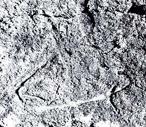
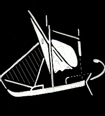
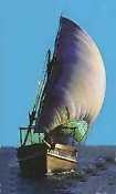
A schematic of the drawing (above) and an actual Arabian dhow (below).
This
Web Directory will always be dynamic ~
all details are flexible and changing