![]()
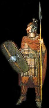
the Celts
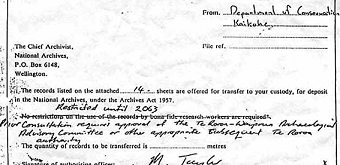
Above
a letter from the Dept of Conservation to the National Archives in Wellington
restricting access to material on a geographical site, as shown at celticnz.co.nz.
"Restricted until 2063" it says.
Why ?
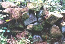
The site is at Waipoua Forest. The Government have declared that this site contains nothing but natural rock formations. Look at the image below, one of 2,000 structures, on 600 sites within an area of 500 acres. Does it look naturally formed to you?
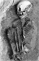
Standing stones and other megalithic structures like stone dome-shaped houses have been found in New Zealand, and more interestingly - red, brown, and blonde-haired Indo-European skeletons have been found in burial caves. Long, long, long before traditionally they should have been in the country!
 \
\
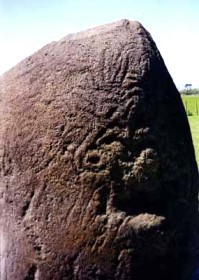
Below is a standing stone, the Puniho stone, found on a Taranaki marae. The inscriptions are not Maori. Who incised it ?
Now, if everybody is sitting comfortably, we'll tell a story. Our story (abridged from New Zealand, a Celtic Country) begins thus:
"Taine Ruaridh Mhor (lit, the big cattle farmer) was delivered by three seagoing longships to NZ in the 12th Century, with 95 of his family and kinfolk and followers, and his sons Rory and Ruaridh.
It was deliberate but not by choice - banishment was not an uncommon feature of the times. In this case the term was for seven generations after he had been incacerated in a dungeon for three years already by his friend King Alexander I of Scotland (reigned 1107-1124AD).
Both Islands of New Zealand were chosen because one of the criteria was that the land for the banishment had to be uninhabited at the time, which NZ was assumed to be.
Men in Taine's lineage were often well over 7 foot tall and generally had red hair, blue eyes and fair complexions. They had been provided with a very small number of sheep and cattle, and enough provisions to last three months, but no tools.
It is said Taine was responsible for introducing particular trees and that there may be connection between Taine and "Tane" the name used by Maoris for the God of the forest. Taine in old Gaelic is apparently pronounced the same as Tane in Maori."
After sailing probably from Fifeshire, on the East coast of Scotland, the fleet of three ships sailed north to Orkney. They then sailed the length of the Atlantic and around the south of Africa. The voyagers passed by the Australian coast indicated by a large land with a lack of fresh water and the presence of black people.
The voyagers then reached what is now New Zealand and passed through what is now Cook Strait. This determined there were two separate pieces of land. The voyage then continued south and around the southern reaches of the South island until the land that was similar to Thule (ie Norway and also land west of Greenland and North of Baffin island). This is New Zealand's region of fjords now known as Fiordland and it was passed as they again sailed north.
They came to a region that had recently been subjected to earthquakes, such that much rock had fallen from high mountains. On passing the worst of the earthquake damage they came to a narrow coastal plain from which the mountains rose steeply, but which permitted sufficient room between mountains and sea to set up a settlement. The cattle were able to be there without being able to wander away - the mountains behind, the sea in front and streams to north and south prevented wandering.
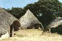
There was plentiful loose rock suitable for building a dwelling in the style of a Scottish black house capable of housing 45 people plus animals. (In a black house the cattle occupied one end of the dwelling and the people the other which had a hearth usually no chimney or windows. The roof of such dwellings were vegetation over beams covered by turf - often quite thick.
Smoke from the fire was often just left to filter out through the roof rather than having a full open chimney. This smoky environment provides inhabitants some protection from sandflies/biting midges as would definately be required in South Westland). An alternative temporary dwelling may have made by the typical method of overturning one of the Viking ships and supporting it on two rows of rocks which follow the lines of the ships strakes thus leaving the outline of a boat. This style is common wherever Vikings or seafarers of the time had stop overs. As there were 90 people to be settled in two separate places in the new land, when the initial dwelling was complete, it was time to leave 45 behind with their share of the animals and to take the other 45 north to the other separate piece of land (now known as the North Island).
The two troublesome sons Rory and Ruaridh were to be separated and not to have any means of communication. A settlement was established in the North Island and it is quite possible a place somewhere near Kawhia or Raglan was chosen (or even further north near the Hokianga Harbour). The journal of the voyage indicates Mt Egmont (or Taranaki - it is possible Tara naki has gaelic roots, "tara" meaning a high place in gaelic) had smoke coming from it. Being aware what volcanoes could do, the voyagers with the second group of 45 proceeded further north for safety. There is sufficient evidence in the Kawhia Raglan region to suggest the probability of initial settlement in this area, but only the opportunity and execution of open archaeological investigation can confirm this.
With both groups provided with a dwelling and their animals, plus some plants and seeds, they were now abandoned to the will of God.
The plants were the Orkney Beech (now extinct in Orkney and on the Scottish mainland - was this the tree called "iron wood" that Cumberlands men so effectively eliminated from Scotland?), the Rowan tree and the linen flax plant. There were also rye, oats, barley and probably the grain called beer in Scotland, as well a some grasses (seed) that would help nourish the cattle. Some grass seeds were also used for medicinal purposes and nettle would have been included (nettle grows in the NZ scrub and bushlands to this day).
The first settlement suffered immensely from incessant rains and was ultimately abandoned for better conditions further north. But it was a long time before communication between the two separate groups was achieved as the lack of tools meant conditions and any seacraft were very primitive until the opportunity for trade occurred - which it did with other voyagers like the Portuguese.
So began possibly the first European settlement of NZ. Genetic traces of these Scots folk are still evident in Maori - those of tall stature, red hair and fairer skin, even blue eyes. Often thought to be of modern European Maori interbreeding. Old Maori well know of this older genetic trait that predates modern European settlement by many generations. "
Du Fresne had remarked how it was uncanny to find Maori wit fair skin, and red hair.
An excellent website with more information on ancient Celtic New Zealanders is here. The author has contributed this letter to viewzone.com, expressing examples of official "cover ups":
"In the last few years New Zealand teams have removed/ buried/ concealed: A trilithon/ obelisk arrangement, composed of about 5 component sets, from the Wairaki area of New Zealand's central North Island. The "Artiamuri Stones", registered by Captain Mair in the 1800's and described by him as the 2nd most significant site he'd seen in New Zealand...these were, seemingly, pushed into a river by a "Forestry Department" bulldozer.
A number of burial caves containing large stature skeletons with red, brown & blond hair. These skeletal remains are a most unwelcome find, as the ancient individuals were very definitely of Indo-European ethnic origin. Platted samples of their red or brown hair used to be on display at the Auckland Museum...but have long since been removed from public scrutiny.
An ancient stone jetty on a northern river estuary. A beautifully hollowed out and fashioned communal dwelling/ assembly area in a limestone cliff. This was at Castlehill in New Zealand's South Island. A friend who revisited it in recent weeks found that the entranceway had been collapsed...undoubtedly by explosives."
This
Web Directory will always be dynamic ~
all details are flexible and changing